Geolocate

Matuber topographic map

Click on the map to display elevation.

About this map

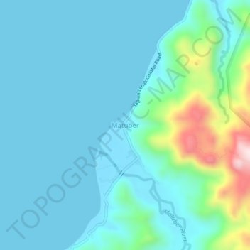
Name: Matuber topographic map, elevation, terrain.

Location: Matuber, Maguindanao del Norte, Bangsamoro, Philippines (7.08915 124.02151 7.12915 124.06151)

Average elevation: 73 m

Minimum elevation: -1 m

Maximum elevation: 458 m

Other topographic maps

Click on a map to view its topography, its elevation and its terrain.

Gear up for your next adventure:

👟Leg Gaiters - Keep debris, mud, and snow out of your boots
👟Sport Hiking Sandals - Breathable footwear for water crossings and camp rest
🌬️Windproof Camp Stove - Efficient cooking even on exposed mountain peaks
🗺️Topographic Maps - Detailed maps to explore trails, mountains, and wilderness areas
🧢Outdoor Cap - Protective cap for sun and rain during hikes

As an Amazon Associate, this site earns from qualifying purchases at no extra cost to you.