
Make a donation
Gear up for your next adventure:
As an Amazon Associate, this site earns from qualifying purchases at no extra cost to you.
Kinlochleven topographic map
Click on the map to display elevation.
Make a donation
Gear up for your next adventure:
As an Amazon Associate, this site earns from qualifying purchases at no extra cost to you.
Kinlochleven
Work on the dam and water supply system began in 1905 and was completed in 1907. The hydro-electric scheme was constructed for the British Aluminium Company and was designed by engineer brothers Patrick and Charles Meik. The chief assistant resident engineer on the project was a young William Halcrow. The scheme involved the construction of a gravity dam over 914 m long (the longest in the Highlands) and 27 m high, creating the Blackwater Reservoir. It was built at an elevation of over 305 m in rugged and almost inaccessible terrain, and involved the construction of some 6 km of concrete aqueduct and nearly 13 km of steel pipe. It has been described as the last major creation of the traditional 'navvy' whose activities in the construction of canals and railways left an indelible mark on the British countryside.
Make a donation
Gear up for your next adventure:
As an Amazon Associate, this site earns from qualifying purchases at no extra cost to you.
About this map
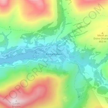
Name: Kinlochleven topographic map, elevation, terrain.
Location: Kinlochleven, Highland, Scotland, PH50 4QH, United Kingdom (56.69430 -4.98478 56.73430 -4.94478)
Average elevation: 306 m
Minimum elevation: -2 m
Maximum elevation: 865 m
Make a donation
Gear up for your next adventure:
As an Amazon Associate, this site earns from qualifying purchases at no extra cost to you.