Geolocate

Mount Paco topographic map

Click on the map to display elevation.

Mount Paco

Paco is an inactive volcano, 524 metres (1,719 ft) in elevation, located at 9°35.6' North, 125°31.1' East, in the province of Surigao del Norte, region of Caraga, island of Mindanao, the Philippines.

Wikipedia (CC-BY-SA 3.0)

About this map

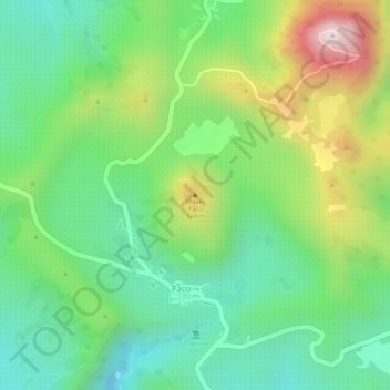
Name: Mount Paco topographic map, elevation, terrain.

Location: Mount Paco, Paco, Surigao del Norte, Caraga, Philippines (9.59326 125.52053 9.59336 125.52063)

Average elevation: 386 m

Minimum elevation: 211 m

Maximum elevation: 674 m

Gear up for your next adventure:

🧤Thermal Hiking Gloves - Grip-enhanced gloves for cold-weather altitude trekking
🧥Ultralight Puffy Jacket - Maximum warmth that packs down to the size of an orange
🧥Softshell Jacket - Windproof and breathable jacket for hiking
🚑Survival Whistle - Signal for help across long distances in mountains
🥾Trail Running Shoes - Lightweight and durable shoes for trail running

As an Amazon Associate, this site earns from qualifying purchases at no extra cost to you.