Geolocate

Trier topographic map

Click on the map to display elevation.

About this map

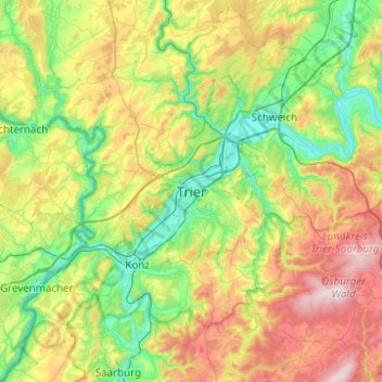
Name: Trier topographic map, elevation, terrain.

Location: Trier, Rhineland-Palatinate, 54290, Germany (49.59962 6.48419 49.91962 6.80419)

Average elevation: 314 m

Minimum elevation: 112 m

Maximum elevation: 712 m

Gear up for your next adventure:

🥘Camping Cookware Set - Compact nesting pots and pans for trail cooking
🧦Outdoor Socks - Durable socks designed for hiking and outdoor sports
🧴Outdoor Sunscreen - High SPF protection for high-altitude UV exposure
🎒Fully Waterproof Backpack - Total protection for photography gear and electronics
🔭Compact Monocular - One-handed bird watching and trail spotting

As an Amazon Associate, this site earns from qualifying purchases at no extra cost to you.