Geolocate

Pönitz topographic map

Click on the map to display elevation.

About this map

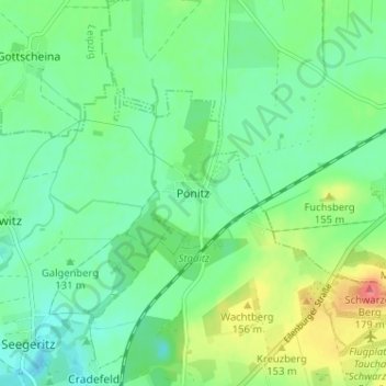
Name: Pönitz topographic map, elevation, terrain.

Location: Pönitz, Taucha, Nordsachsen, Sachsen, 04425, Deutschland (51.39119 12.48725 51.43119 12.52725)

Average elevation: 134 m

Minimum elevation: 113 m

Maximum elevation: 178 m

Gear up for your next adventure:

💧Hydration Bladder - Hands-free hydration solution for long treks
🚑Survival Whistle - Signal for help across long distances in mountains
Lightweight Backpacking Tent - Compact tent for efficient hiking trips
🥾Lightweight Hiking Shoes - Comfortable shoes for day hikes
Tent Footprint - Protect tent floor and increase durability

As an Amazon Associate, this site earns from qualifying purchases at no extra cost to you.