Geolocate

Carnesville topographic map

Click on the map to display elevation.

About this map

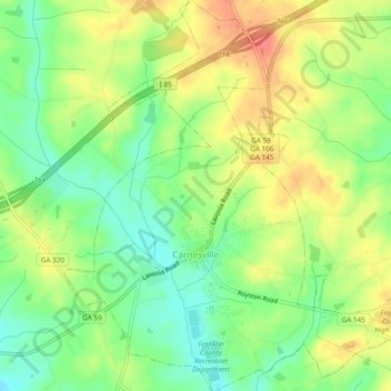
Name: Carnesville topographic map, elevation, terrain.

Location: Carnesville, Franklin County, Georgia, United States (34.35603 -83.25127 34.39540 -83.20665)

Average elevation: 223 m

Minimum elevation: 192 m

Maximum elevation: 258 m

Other topographic maps

Click on a map to view its topography, its elevation and its terrain.

Prospect

United States > Georgia > Franklin County

Average elevation: 233 m

Martin Pond

United States > Georgia > Franklin County

Average elevation: 226 m

Ashland

United States > Georgia > Franklin County

Average elevation: 236 m

Gear up for your next adventure:

🥾Trail Hiking Socks - Comfortable socks to prevent blisters and fatigue
🥘Camping Cookware Set - Compact nesting pots and pans for trail cooking
🌬️Windproof Camp Stove - Efficient cooking even on exposed mountain peaks
💧Collapsible Water Bottle - Space-saving water bottle for outdoor activities
🧥Thermal Layer - Insulating layer for cold outdoor conditions

As an Amazon Associate, this site earns from qualifying purchases at no extra cost to you.