
Make a donation
Gear up for your next adventure:
As an Amazon Associate, this site earns from qualifying purchases at no extra cost to you.
Rinnen topographic map
Click on the map to display elevation.
Make a donation
Gear up for your next adventure:
As an Amazon Associate, this site earns from qualifying purchases at no extra cost to you.
Rinnen
Rinnen ist ein Ortsteil der Gemeinde Kall im nordrhein-westfälischen Kreis Euskirchen rund 350 Einwohnern. Nördlich liegt die Anhöhe Pferdekopf (527,4 m ü. NHN), westlich der Frohnrather Kopf (512,1 m ü. NHN) und östlich ein Kalksteinbruch.
Make a donation
Gear up for your next adventure:
As an Amazon Associate, this site earns from qualifying purchases at no extra cost to you.
About this map
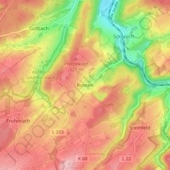
Name: Rinnen topographic map, elevation, terrain.
Average elevation: 480 m
Minimum elevation: 376 m
Maximum elevation: 552 m
Make a donation
Gear up for your next adventure:
As an Amazon Associate, this site earns from qualifying purchases at no extra cost to you.
Other topographic maps
Click on a map to view its topography, its elevation and its terrain.
Sistiger Heide
Deutschland > Nordrhein-Westfalen > Kreis Euskirchen > Kall > Benenberg
Average elevation: 570 m