Geolocate

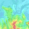
Tulcea topographic map

Click on the map to display elevation.

About this map
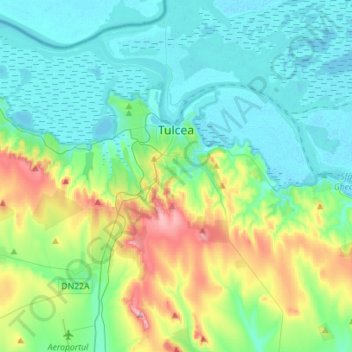
Name: Tulcea topographic map, elevation, terrain.

Location: Tulcea, Romania (45.05305 28.68709 45.24977 28.91299)

Average elevation: 51 m

Minimum elevation: -2 m

Maximum elevation: 220 m

Other topographic maps

Click on a map to view its topography, its elevation and its terrain.

Canalul Lipovenilor

Romania > Tulcea

Average elevation: 12 m

Tulcea

Romania > Tulcea

Average elevation: 25 m

Sălcioara

Romania > Tulcea

Average elevation: 16 m

Islazu

Romania > Tulcea > Hamcearca

Average elevation: 184 m

Vasile Alecsandri

Romania > Tulcea

Average elevation: 258 m

Dealul cu Drum

Romania > Tulcea > Greci

Average elevation: 168 m

Pătlăgeanca

Romania > Tulcea

Average elevation: 4 m

Caraorman

Romania > Tulcea

Average elevation: 1 m

Pietrosu Mic

Romania > Tulcea > Luncavița

Average elevation: 308 m

La Tene

Romania > Tulcea > Cârjelari

Average elevation: 217 m

Lăstuni

Romania > Tulcea

Average elevation: 36 m

Cataloi

Romania > Tulcea

Average elevation: 58 m

Gear up for your next adventure:

🧢Outdoor Cap - Protective cap for sun and rain during hikes
🥾Approach Boots - Comfortable boots for hiking and climbing approaches
🔪Outdoor Multitool - Versatile tool for repairs and food prep in the wild
🌬️Windproof Camp Stove - Efficient cooking even on exposed mountain peaks
👟Trail Running Shoes - Agile footwear for fast-paced topographic exploration

As an Amazon Associate, this site earns from qualifying purchases at no extra cost to you.