
Thank you for supporting this site ❤️
Make a donation
Make a donation
Gear up for your next adventure:
As an Amazon Associate, this site earns from qualifying purchases at no extra cost to you.
Ermeton-sur-Biert topographic map
Click on the map to display elevation.
Thank you for supporting this site ❤️
Make a donation
Make a donation
Gear up for your next adventure:
As an Amazon Associate, this site earns from qualifying purchases at no extra cost to you.
About this map
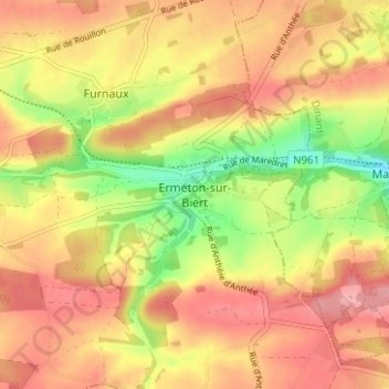
Name: Ermeton-sur-Biert topographic map, elevation, terrain.
Location: Ermeton-sur-Biert, Mettet, Namen, Wallonië, 5644, België (50.27754 4.69979 50.31754 4.73979)
Average elevation: 247 m
Minimum elevation: 182 m
Maximum elevation: 289 m
Thank you for supporting this site ❤️
Make a donation
Make a donation
Gear up for your next adventure:
As an Amazon Associate, this site earns from qualifying purchases at no extra cost to you.
Other topographic maps
Click on a map to view its topography, its elevation and its terrain.