
Make a donation
Gear up for your next adventure:
As an Amazon Associate, this site earns from qualifying purchases at no extra cost to you.
Sour El Ghozlane topographic map
Click on the map to display elevation.
Make a donation
Gear up for your next adventure:
As an Amazon Associate, this site earns from qualifying purchases at no extra cost to you.
Sour El Ghozlane
On the other hand, its administrative and military status reveals that it was definitively subjected to the order of the Roman Empire with the status of autonomous city of the Roman province (free zone: region of Algiers to Bou-Saada) caesarean. Auzia is a large city of ovoid form, destined to serve as capital in this region of central Algeria, Auguste had it endowed with several public edifices: a forum (present room of the festivals), several temples, a curia, a market, a theater and large thermal baths. Auzia was erected on a hill at a moderate altitude, where to this day a wall was in good condition in some places, revealing a kind of citadel which protected the inhabitants.
Make a donation
Gear up for your next adventure:
As an Amazon Associate, this site earns from qualifying purchases at no extra cost to you.
About this map
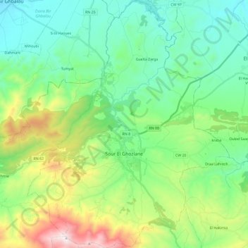
Name: Sour El Ghozlane topographic map, elevation, terrain.
Location: Sour El Ghozlane, Sour El Ghozlane District, Bouira, Algeria (36.07590 3.60055 36.26362 3.79039)
Average elevation: 934 m
Minimum elevation: 609 m
Maximum elevation: 1,807 m
Make a donation
Gear up for your next adventure:
As an Amazon Associate, this site earns from qualifying purchases at no extra cost to you.