
Make a donation
Gear up for your next adventure:
As an Amazon Associate, this site earns from qualifying purchases at no extra cost to you.
Petershausen topographic map
Click on the map to display elevation.
Make a donation
Gear up for your next adventure:
As an Amazon Associate, this site earns from qualifying purchases at no extra cost to you.
About this map
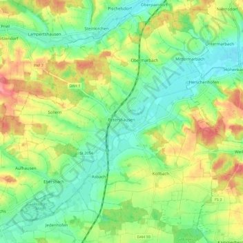
Name: Petershausen topographic map, elevation, terrain.
Location: Petershausen, Landkreis Dachau, Bayern, 85238, Deutschland (48.37492 11.42100 48.44155 11.53073)
Average elevation: 481 m
Minimum elevation: 449 m
Maximum elevation: 530 m
Make a donation
Gear up for your next adventure:
As an Amazon Associate, this site earns from qualifying purchases at no extra cost to you.
Other topographic maps
Click on a map to view its topography, its elevation and its terrain.
Make a donation
Gear up for your next adventure:
As an Amazon Associate, this site earns from qualifying purchases at no extra cost to you.
Make a donation
Gear up for your next adventure:
As an Amazon Associate, this site earns from qualifying purchases at no extra cost to you.
Make a donation
Gear up for your next adventure:
As an Amazon Associate, this site earns from qualifying purchases at no extra cost to you.
Make a donation
Gear up for your next adventure:
As an Amazon Associate, this site earns from qualifying purchases at no extra cost to you.
Make a donation
Gear up for your next adventure:
As an Amazon Associate, this site earns from qualifying purchases at no extra cost to you.
Ruppertskirchen
Deutschland > Bayern > Landkreis Dachau > Röckersberg
Ruppertskirchen liegt auf einer Höhe von etwa 480 m ü. NN, besteht aus neun Wohngebäuden und hat derzeit ca. 20 Einwohner.
Average elevation: 507 m
Make a donation
Gear up for your next adventure:
As an Amazon Associate, this site earns from qualifying purchases at no extra cost to you.
Kiemertshofen
Deutschland > Bayern > Landkreis Dachau
Kiemertshofen befindet sich in 532 Metern Höhe im Westen des Gemeindegebiets von Altomünster und grenzt an die Gemeinde Sielenbach. Straßenverbindungen bestehen zur Kerngemeinde Altomünster, nach Odelzhausen, Sielenbach und Adelzhausen. Die Straßenbezeichnung „Alter Römerweg“ erinnert an eine…
Average elevation: 514 m
Make a donation
Gear up for your next adventure:
As an Amazon Associate, this site earns from qualifying purchases at no extra cost to you.
Gut Häusern
Deutschland > Bayern > Landkreis Dachau > Markt Indersdorf > Straßbach
Average elevation: 486 m
Make a donation
Gear up for your next adventure:
As an Amazon Associate, this site earns from qualifying purchases at no extra cost to you.
Make a donation
Gear up for your next adventure:
As an Amazon Associate, this site earns from qualifying purchases at no extra cost to you.
Make a donation
Gear up for your next adventure:
As an Amazon Associate, this site earns from qualifying purchases at no extra cost to you.
Make a donation
Gear up for your next adventure:
As an Amazon Associate, this site earns from qualifying purchases at no extra cost to you.
Albersbach
Deutschland > Bayern > Landkreis Dachau > Markt Indersdorf > Westerholzhausen
Average elevation: 489 m