Geolocate

Algona topographic map

Click on the map to display elevation.

About this map

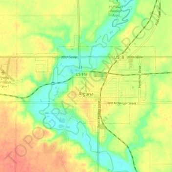
Name: Algona topographic map, elevation, terrain.

Location: Algona, Kossuth County, Iowa, 50511, United States (43.05469 -94.28195 43.09047 -94.19967)

Average elevation: 361 m

Minimum elevation: 335 m

Maximum elevation: 385 m

Gear up for your next adventure:

🧥Insulated Jacket - Keep warm in cold outdoor conditions
🧥Waterproof Jacket - Lightweight rain jackets for hiking and outdoor activities
🩹Compact First Aid Kit - Pre-packed essentials for common trail injuries
🔋Solar Power Bank - Keep your GPS and devices charged during long outdoor trips
🚲Handlebar Phone Mount - View topographic-map.com live while cycling

As an Amazon Associate, this site earns from qualifying purchases at no extra cost to you.