
Ado Odo/Ota topographic map
Interactive map
Click on the map to display elevation.
About this map
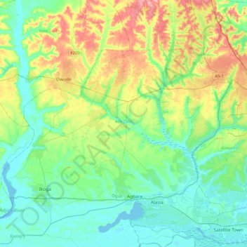
Name: Ado Odo/Ota topographic map, elevation, terrain.
Location: Ado Odo/Ota, Ogun State, 100314, Nigeria (6.49778 2.87866 6.75002 3.28790)
Average elevation: 32 m
Minimum elevation: -3 m
Maximum elevation: 107 m
Other topographic maps
Click on a map to view its topography, its elevation and its terrain.
Ijebu-Igbo
Nigeria > Ogun State > Ijebu North
Ijebu-Igbo, Ijebu North, Ogun State, Nigeria
Average elevation: 87 m
Abeokuta
Nigeria > Ogun State > Abeokuta South
Abeokuta, Abeokuta South, Ogun State, 111101, Nigeria
Average elevation: 95 m
Idiroko
Nigeria > Ogun State > Ipokia > Idiroko
Idiroko, Ipokia, Ogun State, Nigeria
Average elevation: 36 m