
Make a donation
Gear up for your next adventure:
As an Amazon Associate, this site earns from qualifying purchases at no extra cost to you.
Selenge topographic map
Click on the map to display elevation.
Make a donation
Gear up for your next adventure:
As an Amazon Associate, this site earns from qualifying purchases at no extra cost to you.
About this map
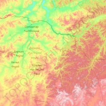
Name: Selenge topographic map, elevation, terrain.
Location: Selenge, Mongolia (48.50478 104.36327 50.47950 108.57140)
Average elevation: 1,146 m
Minimum elevation: 551 m
Maximum elevation: 2,707 m
Make a donation
Gear up for your next adventure:
As an Amazon Associate, this site earns from qualifying purchases at no extra cost to you.
Other topographic maps
Click on a map to view its topography, its elevation and its terrain.
Gobi Desert
The Gobi, broadly defined, can be divided into five distinct dry ecoregions, based on variations in climate and topography.
Average elevation: 1,173 m
Make a donation
Gear up for your next adventure:
As an Amazon Associate, this site earns from qualifying purchases at no extra cost to you.
Make a donation
Gear up for your next adventure:
As an Amazon Associate, this site earns from qualifying purchases at no extra cost to you.