Geolocate

Argentan topographic map

Click on the map to display elevation.

About this map

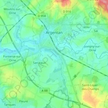
Name: Argentan topographic map, elevation, terrain.

Location: Argentan, Orne, Normandy, Metropolitan France, 61200, France (48.68503 -0.04796 48.76762 0.02200)

Average elevation: 170 m

Minimum elevation: 149 m

Maximum elevation: 244 m

Gear up for your next adventure:

🧢Outdoor Cap - Protective cap for sun and rain during hikes
🍽️Titanium Camping Spork - Ultralight and indestructible eating utensil
Camping Essentials - All-in-one gear for a comfortable camping trip
🦯Trekking Poles - Reduced impact on joints for steep topographic climbs
🩹Moleskin Blister Pads - Direct protection for painful foot pressure points

As an Amazon Associate, this site earns from qualifying purchases at no extra cost to you.