
Yarnell topographic map
Click on the map to display elevation.
About this map
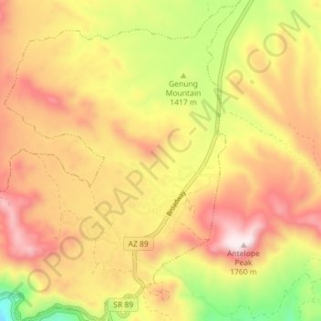
Name: Yarnell topographic map, elevation, terrain.
Location: Yarnell, Yavapai County, Arizona, 85362, United States (34.20124 -112.80092 34.26173 -112.73110)
Average elevation: 1,470 m
Minimum elevation: 1,161 m
Maximum elevation: 1,766 m
Other topographic maps
Click on a map to view its topography, its elevation and its terrain.
Yarnell Hill Fire Memorial Park
United States > Arizona > Yavapai County > Yarnell
Average elevation: 1,498 m