
Râmnicu Vâlcea topographic map
Interactive map
Click on the map to display elevation.
About this map
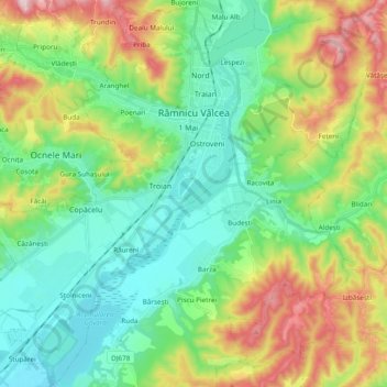
Name: Râmnicu Vâlcea topographic map, elevation, terrain.
Location: Râmnicu Vâlcea, Vâlcea, Romania (45.00934 24.25964 45.14032 24.45027)
Average elevation: 335 m
Minimum elevation: 201 m
Maximum elevation: 628 m
Other topographic maps
Click on a map to view its topography, its elevation and its terrain.
Obârșia Lotrului
Obârșia Lotrului, Voineasa, Vâlcea, Romania
Average elevation: 1,500 m