Geolocate

Dillard topographic map

Click on the map to display elevation.

About this map

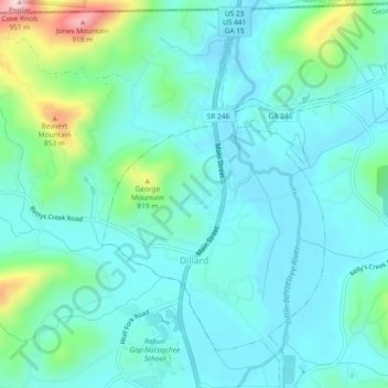
Name: Dillard topographic map, elevation, terrain.

Location: Dillard, Rabun County, Georgia, United States (34.95754 -83.39800 34.99549 -83.35420)

Average elevation: 691 m

Minimum elevation: 635 m

Maximum elevation: 922 m

Other topographic maps

Click on a map to view its topography, its elevation and its terrain.

Lakemont

United States > Georgia > Rabun County

Average elevation: 547 m

Rabun Gap

United States > Georgia > Rabun County

Average elevation: 683 m

Rabun Gap

United States > Georgia > Rabun County

Average elevation: 683 m

Lakemont

United States > Georgia > Rabun County

Average elevation: 547 m

Clayton

United States > Georgia > Rabun County > Clayton

According to the United States Census Bureau, the city has a total area of 3.1 square miles (8.0 km2), all of it land. The elevation of Clayton's downtown area is 1,925 feet (587 m). A number of hilltops within the city limits exceed 2,200 feet.

Average elevation: 634 m

Gear up for your next adventure:

🦶Hiking Shoe Insoles - Added support for high arches and long days on feet
🥾Mountain Hiking Boots - High-traction boots for rocky terrain
🎒Hiking Daypack - Lightweight and durable backpacks for day trips and excursions
💡Portable Camping Lamp - Rechargeable lamp for campsite lighting
🥾Lightweight Hiking Boots - Boots for comfort and mobility on long hikes

As an Amazon Associate, this site earns from qualifying purchases at no extra cost to you.