Geolocate

Pontolo topographic map

Click on the map to display elevation.

About this map
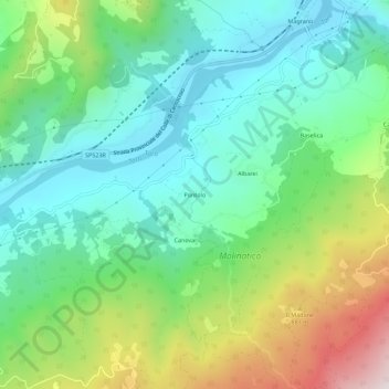
Name: Pontolo topographic map, elevation, terrain.

Location: Pontolo, Borgo Val di Taro, Parma, Emilia-Romagna, Italia (44.47702 9.80609 44.51702 9.84609)

Average elevation: 607 m

Minimum elevation: 343 m

Maximum elevation: 1,200 m

Other topographic maps

Click on a map to view its topography, its elevation and its terrain.
Taro

Italia > Emilia-Romagna > Parma > Borgo Val di Taro

Average elevation: 699 m

Gear up for your next adventure:

🕶️Polarized Sunglasses - Reduces glare from snow and water at high elevations
🧣Merino Neck Gaiter - Protects against wind, sun, and cold at high altitudes
🥾Trail Hiking Shoes - Durable shoes designed for rugged trails
💡Compact LED Flashlight - Powerful and portable flashlight for outdoor use
🛏️Sleeping Bag - Warm and compact sleeping bags for outdoor camping

As an Amazon Associate, this site earns from qualifying purchases at no extra cost to you.