
Make a donation
Gear up for your next adventure:
As an Amazon Associate, this site earns from qualifying purchases at no extra cost to you.
Boësse topographic map
Click on the map to display elevation.
Make a donation
Gear up for your next adventure:
As an Amazon Associate, this site earns from qualifying purchases at no extra cost to you.
About this map
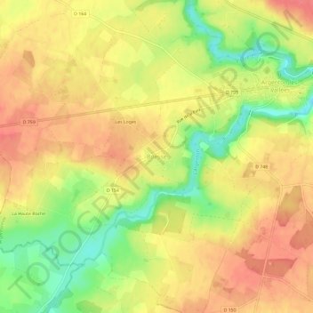
Name: Boësse topographic map, elevation, terrain.
Average elevation: 118 m
Minimum elevation: 79 m
Maximum elevation: 143 m
Make a donation
Gear up for your next adventure:
As an Amazon Associate, this site earns from qualifying purchases at no extra cost to you.
Other topographic maps
Click on a map to view its topography, its elevation and its terrain.
Argenton-les-Vallées
France > Nouvelle-Aquitaine > Deux-Sèvres > Argentonnay
Son altitude minimale, 70 mètres, se situe à l'extrême nord-est, là où l'Argenton reçoit la Madoire et quitte le territoire communal pour servir de limite entre Le Breuil-sous-Argenton et Moutiers-sous-Argenton. Le point culminant, 139 mètres, se trouve au sud-est, en bordure de la route départementale…
Average elevation: 121 m
Moutiers-sous-Argenton
France > Nouvelle-Aquitaine > Deux-Sèvres > Argentonnay
Average elevation: 117 m
Le Breuil-sous-Argenton
France > Nouvelle-Aquitaine > Deux-Sèvres > Argentonnay
Average elevation: 120 m
Make a donation
Gear up for your next adventure:
As an Amazon Associate, this site earns from qualifying purchases at no extra cost to you.