
Schnann topographic map
Interactive map
Click on the map to display elevation.
About this map
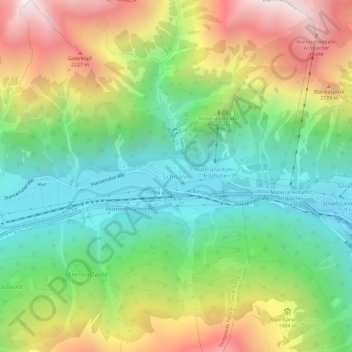
Name: Schnann topographic map, elevation, terrain.
Average elevation: 1,668 m
Minimum elevation: 1,133 m
Maximum elevation: 2,518 m
Other topographic maps
Click on a map to view its topography, its elevation and its terrain.
Pettneu am Arlberg
Autriche > Tyrol > Bezirk Landeck > Gemeinde Pettneu am Arlberg
Pettneu am Arlberg, Gemeinde Pettneu am Arlberg, Bezirk Landeck, Tyrol, 6574, Autriche
Average elevation: 1,614 m