Geolocate

The Sage topographic map

Click on the map to display elevation.

About this map

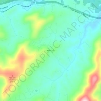
Name: The Sage topographic map, elevation, terrain.

Location: The Sage, Fauquier County, Virginia, 20144, United States (38.86928 -77.98222 38.90928 -77.94222)

Average elevation: 224 m

Minimum elevation: 147 m

Maximum elevation: 423 m

Other topographic maps

Click on a map to view its topography, its elevation and its terrain.

Warrenton

United States > Virginia > Fauquier County

Average elevation: 159 m

The Plains

United States > Virginia > Fauquier County

Average elevation: 180 m

Cedar Run

United States > Virginia > Fauquier County

Average elevation: 75 m

Remington

United States > Virginia > Fauquier County

Average elevation: 88 m

Warrenton

United States > Virginia > Fauquier County

Average elevation: 159 m

The Plains

United States > Virginia > Fauquier County

Average elevation: 180 m

The Plains

United States > Virginia > Fauquier County

Average elevation: 180 m

The Plains

United States > Virginia > Fauquier County

Average elevation: 180 m

Warrenton

United States > Virginia > Fauquier County

Average elevation: 159 m

Warrenton

United States > Virginia > Fauquier County

Average elevation: 159 m

Gear up for your next adventure:

🚲Handlebar Phone Mount - View topographic-map.com live while cycling
🛁Quick-Dry Microfiber Towel - Space-saving towel that dries rapidly on the move
Bushcraft Tarp - Versatile emergency shelter or gear protection
🥾Hiking Gaiters - Protect legs and shoes from mud, snow, and debris
🥾Hiking Leggings - Comfortable leggings for outdoor activities

As an Amazon Associate, this site earns from qualifying purchases at no extra cost to you.