
Thank you for supporting this site ❤️
Make a donation
Make a donation
Gear up for your next adventure:
As an Amazon Associate, this site earns from qualifying purchases at no extra cost to you.
Zhuangyuan topographic map
Click on the map to display elevation.
Thank you for supporting this site ❤️
Make a donation
Make a donation
Gear up for your next adventure:
As an Amazon Associate, this site earns from qualifying purchases at no extra cost to you.
About this map
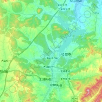
Name: Zhuangyuan topographic map, elevation, terrain.
Location: Zhuangyuan, Qixia City, Yantai, Shandong, 265300, China (37.29754 120.76069 37.37937 120.90926)
Average elevation: 192 m
Minimum elevation: 83 m
Maximum elevation: 511 m
Thank you for supporting this site ❤️
Make a donation
Make a donation
Gear up for your next adventure:
As an Amazon Associate, this site earns from qualifying purchases at no extra cost to you.