Geolocate

Siret topographic map

Click on the map to display elevation.

About this map

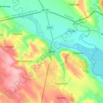
Name: Siret topographic map, elevation, terrain.

Location: Siret, Suceava, Romania (47.91488 25.99333 47.98802 26.13112)

Average elevation: 346 m

Minimum elevation: 290 m

Maximum elevation: 437 m

Gear up for your next adventure:

🛌Down Sleeping Bag - Superior warmth-to-weight ratio for cold nights
🧥Thermal Fleece Jacket - Versatile insulation for changing mountain temperatures
🧴Outdoor Sunscreen - High SPF protection for high-altitude UV exposure
🔋Lithium AA Batteries - Long-lasting power that performs in extreme cold
🧥Packable Rain Jacket - Breathable waterproof layer for unpredictable weather

As an Amazon Associate, this site earns from qualifying purchases at no extra cost to you.