Geolocate

Omamari topographic map

Click on the map to display elevation.

About this map

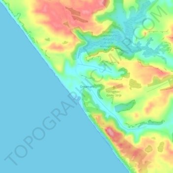
Name: Omamari topographic map, elevation, terrain.

Location: Omamari, Kaipara District, Northland, New Zealand (-35.88478 173.64838 -35.84478 173.68838)

Average elevation: 36 m

Minimum elevation: 0 m

Maximum elevation: 127 m

Other topographic maps

Click on a map to view its topography, its elevation and its terrain.

Wairoa River

New Zealand > Northland > Kaipara District

Average elevation: 42 m

Lake Kaiiwi

New Zealand > Northland > Kaipara District

Average elevation: 79 m

Lake Rototuna

New Zealand > Northland > Kaipara District

Average elevation: 120 m

Gear up for your next adventure:

🥾Trekking Boots - Durable boots for long-distance trekking
Lightweight Camping Tent - Portable shelter optimized for Canadian backcountry camping
🧢Hiking Sun Hat - Wide-brimmed protection for exposed mountain ridges
🧥Fleece Jacket - Warm and lightweight jacket for layering
🔦LED Headlamp - Hands-free lighting for early morning starts or late finishes

As an Amazon Associate, this site earns from qualifying purchases at no extra cost to you.