
Thank you for supporting this site ❤️
Make a donation
Make a donation
Gear up for your next adventure:
As an Amazon Associate, this site earns from qualifying purchases at no extra cost to you.
Ikhetaben topographic map
Click on the map to display elevation.
Thank you for supporting this site ❤️
Make a donation
Make a donation
Gear up for your next adventure:
As an Amazon Associate, this site earns from qualifying purchases at no extra cost to you.
About this map
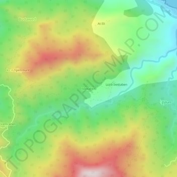
Name: Ikhetaben topographic map, elevation, terrain.
Location: Ikhetaben, Toudja, Daïra El Kseur, Béjaïa, 06030, Algérie (36.82079 4.82169 36.86079 4.86169)
Average elevation: 304 m
Minimum elevation: 0 m
Maximum elevation: 729 m
Thank you for supporting this site ❤️
Make a donation
Make a donation
Gear up for your next adventure:
As an Amazon Associate, this site earns from qualifying purchases at no extra cost to you.