
Thank you for supporting this site ❤️
Make a donation
Make a donation
Gear up for your next adventure:
As an Amazon Associate, this site earns from qualifying purchases at no extra cost to you.
Chullupampa topographic map
Click on the map to display elevation.
Thank you for supporting this site ❤️
Make a donation
Make a donation
Gear up for your next adventure:
As an Amazon Associate, this site earns from qualifying purchases at no extra cost to you.
About this map
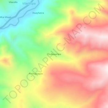
Name: Chullupampa topographic map, elevation, terrain.
Location: Chullupampa, San Antón, Azángaro, Puno, Perú (-14.55575 -70.27629 -14.51575 -70.23629)
Average elevation: 4,376 m
Minimum elevation: 3,991 m
Maximum elevation: 4,730 m
Thank you for supporting this site ❤️
Make a donation
Make a donation
Gear up for your next adventure:
As an Amazon Associate, this site earns from qualifying purchases at no extra cost to you.