
Thank you for supporting this site ❤️
Make a donation
Make a donation
Gear up for your next adventure:
As an Amazon Associate, this site earns from qualifying purchases at no extra cost to you.
Vigliano topographic map
Click on the map to display elevation.
Thank you for supporting this site ❤️
Make a donation
Make a donation
Gear up for your next adventure:
As an Amazon Associate, this site earns from qualifying purchases at no extra cost to you.
About this map
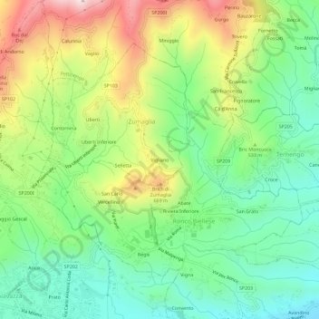
Name: Vigliano topographic map, elevation, terrain.
Location: Vigliano, Zumaglia, Biella, Piemonte, 13845, Italia (45.56902 8.07265 45.60902 8.11265)
Average elevation: 492 m
Minimum elevation: 303 m
Maximum elevation: 809 m
Thank you for supporting this site ❤️
Make a donation
Make a donation
Gear up for your next adventure:
As an Amazon Associate, this site earns from qualifying purchases at no extra cost to you.