
Thank you for supporting this site ❤️
Make a donation
Make a donation
Gear up for your next adventure:
As an Amazon Associate, this site earns from qualifying purchases at no extra cost to you.
Benferri topographic map
Click on the map to display elevation.
Thank you for supporting this site ❤️
Make a donation
Make a donation
Gear up for your next adventure:
As an Amazon Associate, this site earns from qualifying purchases at no extra cost to you.
About this map
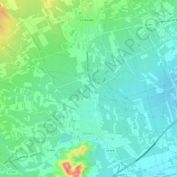
Name: Benferri topographic map, elevation, terrain.
Average elevation: 64 m
Minimum elevation: 31 m
Maximum elevation: 165 m
Thank you for supporting this site ❤️
Make a donation
Make a donation
Gear up for your next adventure:
As an Amazon Associate, this site earns from qualifying purchases at no extra cost to you.
Other topographic maps
Click on a map to view its topography, its elevation and its terrain.
La Mata
Espagne > Communauté Valencienne > el Baix Segura / La Vega Baja > Torrevieja
Average elevation: 5 m
Mil Palmeras
Espagne > Communauté Valencienne > el Baix Segura / La Vega Baja > Orihuela > Dehesa de Campoamor
Average elevation: 19 m