
Make a donation
Gear up for your next adventure:
As an Amazon Associate, this site earns from qualifying purchases at no extra cost to you.
Lagos de Moreno topographic map
Click on the map to display elevation.
Make a donation
Gear up for your next adventure:
As an Amazon Associate, this site earns from qualifying purchases at no extra cost to you.
Lagos de Moreno
Lagos de Moreno has a subtropical highland climate (Köppen climate classification Cwb) with mild temperatures year round. Temperatures are generally similar for any given month, but daily high and low fluctuations can be very sharp in the winter due in part to the city's altitude and its uneven surroundings. Winters are mild with an average maximum temperature of 23 °C (73.4 °F) in January although nighttime temperatures are often cold, with an average minimum temperature of 3 °C (37.4 °F). Many days are sunny, averaging around 15-19 clear days per month and precipitation is low. Nighttime temperatures regularly fall below 0 °C (32.0 °F) but extended periods of frost are rare.
Make a donation
Gear up for your next adventure:
As an Amazon Associate, this site earns from qualifying purchases at no extra cost to you.
About this map
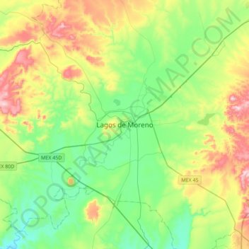
Name: Lagos de Moreno topographic map, elevation, terrain.
Average elevation: 1,956 m
Minimum elevation: 1,789 m
Maximum elevation: 2,305 m
Make a donation
Gear up for your next adventure:
As an Amazon Associate, this site earns from qualifying purchases at no extra cost to you.