
Make a donation
Gear up for your next adventure:
As an Amazon Associate, this site earns from qualifying purchases at no extra cost to you.
Fraubrunnen topographic map
Click on the map to display elevation.
Make a donation
Gear up for your next adventure:
As an Amazon Associate, this site earns from qualifying purchases at no extra cost to you.
About this map
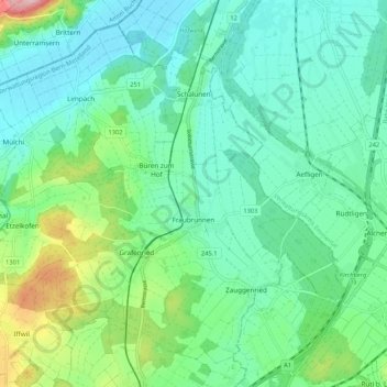
Name: Fraubrunnen topographic map, elevation, terrain.
Average elevation: 511 m
Minimum elevation: 463 m
Maximum elevation: 663 m
Make a donation
Gear up for your next adventure:
As an Amazon Associate, this site earns from qualifying purchases at no extra cost to you.
Other topographic maps
Click on a map to view its topography, its elevation and its terrain.
Schloss Wittigkofen
Switzerland > Bern > Bern-Mittelland administrative district > Bern > Schloss Wittigkofen
Average elevation: 568 m
Make a donation
Gear up for your next adventure:
As an Amazon Associate, this site earns from qualifying purchases at no extra cost to you.
Tannacker
Switzerland > Bern > Bern-Mittelland administrative district > Muri bei Bern > Gümligen
Average elevation: 593 m
Gantrisch
Switzerland > Bern > Bern-Mittelland administrative district > Rüeggisberg
Average elevation: 1,776 m
Rüplisried
Switzerland > Bern > Bern-Mittelland administrative district > Mühleberg
Average elevation: 545 m
Make a donation
Gear up for your next adventure:
As an Amazon Associate, this site earns from qualifying purchases at no extra cost to you.
Rüschegg Gambach
Switzerland > Bern > Bern-Mittelland administrative district
Average elevation: 977 m
Bern
Switzerland > Bern > Bern-Mittelland administrative district > Bern
Bern is built on very uneven ground. An elevation difference of up to 60 metres exists between the inner city districts on the Aare (Matte, Marzili) and the higher ones (Kirchenfeld, Länggasse).
Average elevation: 643 m
Hofen
Switzerland > Bern > Bern-Mittelland administrative district > Wohlen bei Bern
Average elevation: 569 m