
Make a donation
Gear up for your next adventure:
As an Amazon Associate, this site earns from qualifying purchases at no extra cost to you.
Herschdorf topographic map
Click on the map to display elevation.
Make a donation
Gear up for your next adventure:
As an Amazon Associate, this site earns from qualifying purchases at no extra cost to you.
About this map
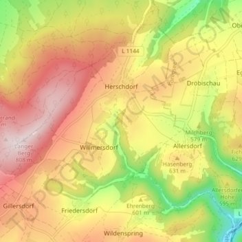
Name: Herschdorf topographic map, elevation, terrain.
Location: Herschdorf, Großbreitenbach, Ilm-Kreis, Thüringen, Deutschland (50.60115 11.01753 50.64367 11.09045)
Average elevation: 609 m
Minimum elevation: 374 m
Maximum elevation: 802 m
Make a donation
Gear up for your next adventure:
As an Amazon Associate, this site earns from qualifying purchases at no extra cost to you.
Other topographic maps
Click on a map to view its topography, its elevation and its terrain.
Ochsenbacher Teich
Deutschland > Thüringen > Ilm-Kreis > Großbreitenbach > Neustadt am Rennsteig
Average elevation: 729 m
Kahlert
Deutschland > Thüringen > Ilm-Kreis > Großbreitenbach
Kahlert liegt in etwa 780 Metern Höhe auf dem Kamm des Thüringer Waldes direkt am Rennsteig, der den Ort in Nord-Süd-Richtung durchzieht. Die Kammhochfläche fällt nach Westen steil zum Tannengrund ab, der in die Talsperre Schönbrunn übergeht. Nach Osten beginnt das Tal der Oelze, die durch Altenfeld…
Average elevation: 711 m