
Make a donation
Gear up for your next adventure:
As an Amazon Associate, this site earns from qualifying purchases at no extra cost to you.
Herpf topographic map
Click on the map to display elevation.
Make a donation
Gear up for your next adventure:
As an Amazon Associate, this site earns from qualifying purchases at no extra cost to you.
About this map
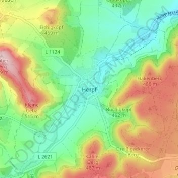
Name: Herpf topographic map, elevation, terrain.
Average elevation: 393 m
Minimum elevation: 298 m
Maximum elevation: 540 m
Make a donation
Gear up for your next adventure:
As an Amazon Associate, this site earns from qualifying purchases at no extra cost to you.
Other topographic maps
Click on a map to view its topography, its elevation and its terrain.
Meiningen
Deutschland > Thüringen > Landkreis Schmalkalden-Meiningen > Meiningen
Meiningen hat eine zentrale Lage in Deutschland und gehört zur länderübergreifenden Region Franken. Die Stadt liegt im Werratal am Ostrand der Rhön auf einer Höhe zwischen 280 m und 470 m. Die Stadt grenzt mit dem Ortsteil Henneberg direkt an den Freistaat Bayern und bis zur hessischen Landesgrenze sind…
Average elevation: 394 m
1
Deutschland > Thüringen > Landkreis Schmalkalden-Meiningen > Meiningen > Meiningen
Average elevation: 358 m