
Make a donation
Gear up for your next adventure:
As an Amazon Associate, this site earns from qualifying purchases at no extra cost to you.
La Beliere topographic map
Click on the map to display elevation.
Make a donation
Gear up for your next adventure:
As an Amazon Associate, this site earns from qualifying purchases at no extra cost to you.
About this map
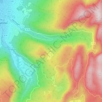
Name: La Beliere topographic map, elevation, terrain.
Average elevation: 803 m
Minimum elevation: 538 m
Maximum elevation: 1,093 m
Make a donation
Gear up for your next adventure:
As an Amazon Associate, this site earns from qualifying purchases at no extra cost to you.
Other topographic maps
Click on a map to view its topography, its elevation and its terrain.
Oyonnax
France > Auvergne-Rhône-Alpes > Ain > Oyonnax
Le massif du Haut-Bugey se situe à l’extrémité méridionale de la chaîne du Jura. Ce secteur est limité par la plaine de l’Ain à l’ouest et par la vallée du Rhône à l’est et s’étend sur une largeur d'environ une cinquantaine de kilomètres avec des altitudes allant de 1 500 m à l’est à…
Average elevation: 763 m
Make a donation
Gear up for your next adventure:
As an Amazon Associate, this site earns from qualifying purchases at no extra cost to you.