
Make a donation
Gear up for your next adventure:
As an Amazon Associate, this site earns from qualifying purchases at no extra cost to you.
Obermillstatt topographic map
Click on the map to display elevation.
Make a donation
Gear up for your next adventure:
As an Amazon Associate, this site earns from qualifying purchases at no extra cost to you.
Obermillstatt
Das Haufendorf am Millstätter Berg liegt in 857 m ü. A. Seehöhe auf einem Hochplateau rund 150 m über dem Millstätter See am Fuße der Millstätter Alpe in den Nockbergen und ist über die B 98 von Millstatt (2 km) bzw. über die L 17 von Dellach oder Seeboden aus erreichbar (Entfernung zur Tauern Autobahn A10 / Knoten Spittal-Millstätter See 9 km). Unmittelbar benachbarte Orte sind Lammersdorf und Kleindombra.
Make a donation
Gear up for your next adventure:
As an Amazon Associate, this site earns from qualifying purchases at no extra cost to you.
About this map
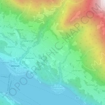
Name: Obermillstatt topographic map, elevation, terrain.
Average elevation: 953 m
Minimum elevation: 584 m
Maximum elevation: 1,886 m
Make a donation
Gear up for your next adventure:
As an Amazon Associate, this site earns from qualifying purchases at no extra cost to you.