
Jardin des Plantes topographic map
Interactive map
Click on the map to display elevation.
About this map
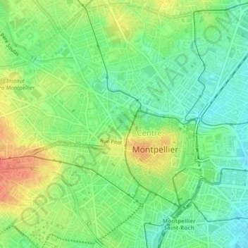
Name: Jardin des Plantes topographic map, elevation, terrain.
Average elevation: 40 m
Minimum elevation: 18 m
Maximum elevation: 68 m
Other topographic maps
Click on a map to view its topography, its elevation and its terrain.
Berges du Lez - Domaine de Lavalette
France > Occitanie > Hérault > Montpellier
Berges du Lez - Domaine de Lavalette, Aiguelongue, Hôpitaux-Facultés, Montpellier, Hérault, Occitanie, France métropolitaine, France
Average elevation: 60 m