
Bowne topographic map
Interactive map
Click on the map to display elevation.
About this map
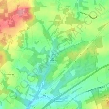
Name: Bowne topographic map, elevation, terrain.
Average elevation: 74 m
Minimum elevation: 34 m
Maximum elevation: 134 m
Other topographic maps
Click on a map to view its topography, its elevation and its terrain.
Linvale
United States > New Jersey > Hunterdon County > East Amwell Township
Linvale, East Amwell Township, Hunterdon County, New Jersey, United States
Average elevation: 109 m
Larisons Corners
United States > New Jersey > Hunterdon County > East Amwell Township
Larisons Corners, East Amwell Township, Hunterdon County, New Jersey, 08551, United States
Average elevation: 66 m
Snydertown
United States > New Jersey > Hunterdon County > East Amwell Township
Snydertown, East Amwell Township, Hunterdon County, New Jersey, 08551, United States
Average elevation: 110 m
Wertsville
United States > New Jersey > Hunterdon County > East Amwell Township
Wertsville, East Amwell Township, Hunterdon County, New Jersey, United States
Average elevation: 72 m
Ringoes
United States > New Jersey > Hunterdon County > East Amwell Township
Ringoes, East Amwell Township, Hunterdon County, New Jersey, 08551, United States
Average elevation: 75 m
Rileyville
United States > New Jersey > Hunterdon County > East Amwell Township
Rileyville, East Amwell Township, Hunterdon County, New Jersey, 08525, United States
Average elevation: 125 m