Geolocate

Saxon topographic map

Click on the map to display elevation.

About this map

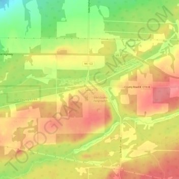
Name: Saxon topographic map, elevation, terrain.

Location: Saxon, Town of Saxon, Iron County, Wisconsin, 54559, United States (46.47257 -90.43375 46.51257 -90.39375)

Average elevation: 339 m

Minimum elevation: 290 m

Maximum elevation: 371 m

Other topographic maps

Click on a map to view its topography, its elevation and its terrain.

Town of Gurney

United States > Wisconsin > Iron County

Average elevation: 318 m

Town of Pence

United States > Wisconsin > Iron County

Average elevation: 485 m

Montreal

United States > Wisconsin > Iron County

Average elevation: 464 m

Town of Kimball

United States > Wisconsin > Iron County

Average elevation: 392 m

Hurley

United States > Wisconsin > Iron County

Hurley was at the center of a boundary dispute between Michigan and Wisconsin, culminating in a United States Supreme Court case in 1926, confirming Hurley belonging to Wisconsin. The Montreal River was mapped in detail in 1841 by Lieutenant Thomas Jefferson Cram of the United States Land Office Department of…

Average elevation: 455 m

Town of Anderson

United States > Wisconsin > Iron County

Average elevation: 467 m

Gear up for your next adventure:

💧Hydration Bladder - Hands-free hydration solution for long treks
🔋Solar Power Bank - Keep your GPS and devices charged during long outdoor trips
🧢Sun Protection Cap - Breathable cap to protect from sun exposure
Tent Footprint - Protect tent floor and increase durability
🛏️Sleeping Bag - Warm and compact sleeping bags for outdoor camping

As an Amazon Associate, this site earns from qualifying purchases at no extra cost to you.