Geolocate

Estillfork topographic map

Click on the map to display elevation.

About this map

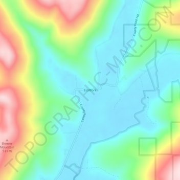
Name: Estillfork topographic map, elevation, terrain.

Location: Estillfork, Jackson County, Alabama, 35745, United States (34.89009 -86.19054 34.93009 -86.15054)

Average elevation: 298 m

Minimum elevation: 194 m

Maximum elevation: 525 m

Other topographic maps

Click on a map to view its topography, its elevation and its terrain.

Langston

United States > Alabama > Jackson County

Average elevation: 243 m

Paint Rock

United States > Alabama > Jackson County

Average elevation: 247 m

Pleasant Groves

United States > Alabama > Jackson County

Average elevation: 331 m

Skyline

United States > Alabama > Jackson County

Average elevation: 389 m

Hytop

United States > Alabama > Jackson County

Average elevation: 413 m

Dutton

United States > Alabama > Jackson County

Average elevation: 410 m

Scottsboro

United States > Alabama > Jackson County

Average elevation: 235 m

Stevenson

United States > Alabama > Jackson County

Average elevation: 247 m

Paint Rock

United States > Alabama > Jackson County

Average elevation: 249 m

Pisgah

United States > Alabama > Jackson County > Pisgah

Average elevation: 419 m

Gear up for your next adventure:

🧢Beanie Hat - Keep your head warm in cold weather
🧴Outdoor Sunscreen - High SPF protection for high-altitude UV exposure
🧦Thermal Socks - Warm socks for winter hiking or camping
👖Convertible Hiking Pants - Zip-off legs to adapt to changing weather conditions
🔪Outdoor Multitool - Versatile tool for repairs and food prep in the wild

As an Amazon Associate, this site earns from qualifying purchases at no extra cost to you.