Geolocate

Salawag topographic map

Click on the map to display elevation.

About this map

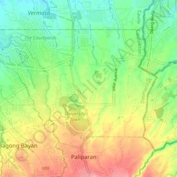
Name: Salawag topographic map, elevation, terrain.

Location: Salawag, Dasmariñas, Cavite, Calabarzon, Philippines (14.32267 120.94872 14.36270 121.00838)

Average elevation: 91 m

Minimum elevation: 49 m

Maximum elevation: 143 m

Other topographic maps

Click on a map to view its topography, its elevation and its terrain.

Mango Village

Philippines > Cavite > Dasmarinas

Average elevation: 63 m

Luksuhin Dam

Philippines > Cavite > Dasmarinas

Average elevation: 127 m

Piela

Philippines > Cavite > Dasmarinas > Piela

Average elevation: 170 m

Humayao

Philippines > Cavite > Dasmarinas

Average elevation: 202 m

Tibagan

Philippines > Cavite > Dasmarinas

Average elevation: 72 m

Pasong Tinta

Philippines > Cavite > Dasmarinas

Average elevation: 79 m

Gear up for your next adventure:

🧰Survival Kit - Essential gear for emergencies in the wilderness
🥾Lightweight Hiking Boots - Boots for comfort and mobility on long hikes
🔋Solar Power Bank - Keep your GPS and devices charged during long outdoor trips
🧴Sunscreen SPF - Broad-spectrum sunscreen for outdoor activities
🛰️Satellite Messenger - Emergency communication for areas with no cell service

As an Amazon Associate, this site earns from qualifying purchases at no extra cost to you.