Geolocate

Fishers topographic map

Click on the map to display elevation.

About this map

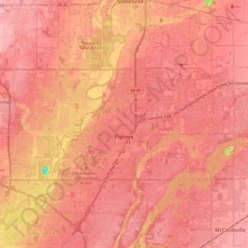
Name: Fishers topographic map, elevation, terrain.

Location: Fishers, Hamilton County, Indiana, United States (39.92696 -86.07655 40.00108 -85.86210)

Average elevation: 246 m

Minimum elevation: 153 m

Maximum elevation: 273 m

Other topographic maps

Click on a map to view its topography, its elevation and its terrain.

West Park

United States > Indiana > Hamilton County > Carmel

Average elevation: 274 m

Aroma

United States > Indiana > Hamilton County

Average elevation: 256 m

Newark Village

United States > Indiana > Hamilton County > Carmel

Average elevation: 254 m

Lake Windemere

United States > Indiana > Hamilton County > Carmel

Average elevation: 273 m

Halifax Park

United States > Indiana > Hamilton County > Carmel

Average elevation: 274 m

Lake Windemere

United States > Indiana > Hamilton County > Carmel

Average elevation: 273 m

Carmel

United States > Indiana > Hamilton County > Carmel > Carmel

Average elevation: 254 m

Gear up for your next adventure:

💧Hydration Pack - Hands-free hydration system for long hikes
🥾Trekking Poles - Adjustable trekking poles to reduce knee stress and improve stability
🧴Waterproofing Spray - Restore the DWR coating on jackets and tents
🚑Survival Whistle - Signal for help across long distances in mountains
Backpacking Tent - Lightweight tent for long-distance hiking trips

As an Amazon Associate, this site earns from qualifying purchases at no extra cost to you.