Geolocate

Wuhan topographic map

Click on the map to display elevation.

About this map

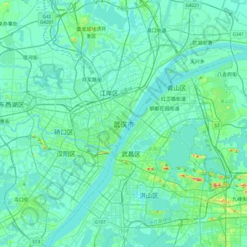
Name: Wuhan topographic map, elevation, terrain.

Location: Wuhan, Jiang'an District, Wuhan City, Hubei, 430062, China (30.43511 114.13994 30.75511 114.45994)

Average elevation: 25 m

Minimum elevation: 11 m

Maximum elevation: 132 m

Other topographic maps

Click on a map to view its topography, its elevation and its terrain.

Huangpi District

China > Hubei > Wuhan

Average elevation: 64 m

Gear up for your next adventure:

🥾All-Terrain Hiking Boots - Versatile boots for varied hiking conditions
🥾Trail Running Boots - Durable shoes designed for trail running
🔦UV Flashlight - Detect minerals or specific insects in the dark
🔦LED Headtorch - Bright and durable light for night activities
🧭GPS Tracker - Track your location in remote areas safely

As an Amazon Associate, this site earns from qualifying purchases at no extra cost to you.