
Make a donation
Gear up for your next adventure:
As an Amazon Associate, this site earns from qualifying purchases at no extra cost to you.
Gondifelos topographic map
Click on the map to display elevation.
Make a donation
Gear up for your next adventure:
As an Amazon Associate, this site earns from qualifying purchases at no extra cost to you.
Gondifelos
A primeira ocupação deste sítio deverá montar aos séculos IX/VIII a.C.. Encontra-se assente num remate de esporão à altitude de 99 m, sobranceiro ao rio Este e a uma grande mancha de terrenos aluviais cuja fertilidade é assinalável.
Make a donation
Gear up for your next adventure:
As an Amazon Associate, this site earns from qualifying purchases at no extra cost to you.
About this map
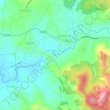
Name: Gondifelos topographic map, elevation, terrain.
Average elevation: 94 m
Minimum elevation: 40 m
Maximum elevation: 227 m
Make a donation
Gear up for your next adventure:
As an Amazon Associate, this site earns from qualifying purchases at no extra cost to you.
Other topographic maps
Click on a map to view its topography, its elevation and its terrain.