Geolocate

Cambados topographic map

Click on the map to display elevation.

About this map

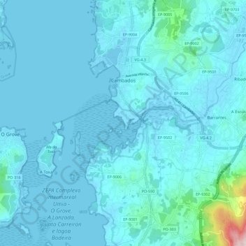
Name: Cambados topographic map, elevation, terrain.

Location: Cambados, O Salnés, Pontevedra, Galicia, Spain (42.45881 -8.83784 42.54107 -8.75617)

Average elevation: 27 m

Minimum elevation: -3 m

Maximum elevation: 401 m

Other topographic maps

Click on a map to view its topography, its elevation and its terrain.

Ardia

Spain > Galicia > O Salnés > O Grove

Average elevation: 20 m

Adina

Spain > Galicia > O Salnés > Adina

Average elevation: 43 m

Gear up for your next adventure:

🔥Emergency Fire Starter - Reliable ignition source for all weather conditions
🧰Emergency Multi-Tool - Compact multi-tool for outdoor survival
🔦LED Headlamp - Hands-free lighting for early morning starts or late finishes
🧢Outdoor Visor - Breathable visor for sunny hikes
💧Hydration Pack - Hands-free hydration system for long hikes

As an Amazon Associate, this site earns from qualifying purchases at no extra cost to you.