
Make a donation
Gear up for your next adventure:
As an Amazon Associate, this site earns from qualifying purchases at no extra cost to you.
Jaffrey topographic map
Click on the map to display elevation.
Make a donation
Gear up for your next adventure:
As an Amazon Associate, this site earns from qualifying purchases at no extra cost to you.
Jaffrey
Thorndike Pond is in the north, and Contoocook Lake is on the southern boundary. Mount Monadnock, elevation 3,165 feet (965 m) and the highest point in Jaffrey as well as Cheshire County, is in the northwest. Jaffrey lies mostly within the Merrimack River watershed, via the Contoocook River in the eastern part of the town, with the northwest corner of town lying in the Ashuelot River watershed, part of the larger Connecticut River watershed.
Make a donation
Gear up for your next adventure:
As an Amazon Associate, this site earns from qualifying purchases at no extra cost to you.
About this map
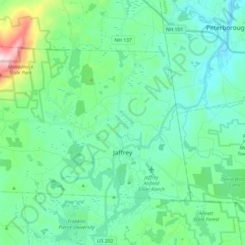
Name: Jaffrey topographic map, elevation, terrain.
Average elevation: 351 m
Minimum elevation: 216 m
Maximum elevation: 940 m
Make a donation
Gear up for your next adventure:
As an Amazon Associate, this site earns from qualifying purchases at no extra cost to you.
Other topographic maps
Click on a map to view its topography, its elevation and its terrain.