
Make a donation
Gear up for your next adventure:
As an Amazon Associate, this site earns from qualifying purchases at no extra cost to you.
Mount Chandler topographic map
Click on the map to display elevation.
Make a donation
Gear up for your next adventure:
As an Amazon Associate, this site earns from qualifying purchases at no extra cost to you.
About this map
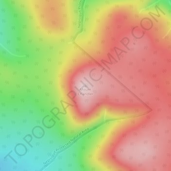
Name: Mount Chandler topographic map, elevation, terrain.
Average elevation: 578 m
Minimum elevation: 381 m
Maximum elevation: 727 m
Make a donation
Gear up for your next adventure:
As an Amazon Associate, this site earns from qualifying purchases at no extra cost to you.
Other topographic maps
Click on a map to view its topography, its elevation and its terrain.
Parc provincial Mont-Carleton
Canada > Nouveau-Brunswick > District rural du Grand-Miramichi > Paroisse de Northesk
Le Parc Provincial du Mont-Carleton est situé à proximité de la ville de Saint-Quentin dans les comtés de Northumberland et Restigouche dans le nord de la province du Nouveau-Brunswick. Le parc occupe 17 000 hectares du territoire néo-Brunswickois, soit le plus grand des 34 parcs provinciaux gérés par…
Average elevation: 428 m