
Make a donation
Gear up for your next adventure:
As an Amazon Associate, this site earns from qualifying purchases at no extra cost to you.
Guarda topographic map
Click on the map to display elevation.
Make a donation
Gear up for your next adventure:
As an Amazon Associate, this site earns from qualifying purchases at no extra cost to you.
Guarda
Culminant à 1 060 mètres d'altitude sur un contrefort oriental de la serra da Estrela, la municipalité de Guarda a une superficie de 717,88 km2 et une population de 42 541 habitants (2011), répartis dans 55 paroisses. Elle est la ville la plus haute du Portugal et est ainsi surnommée Cidade mais alta.
Make a donation
Gear up for your next adventure:
As an Amazon Associate, this site earns from qualifying purchases at no extra cost to you.
About this map
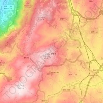
Name: Guarda topographic map, elevation, terrain.
Location: Guarda, Beira Interior Norte, Centre, Portugal (40.50448 -7.29265 40.57389 -7.19806)
Average elevation: 864 m
Minimum elevation: 464 m
Maximum elevation: 1,063 m
Make a donation
Gear up for your next adventure:
As an Amazon Associate, this site earns from qualifying purchases at no extra cost to you.