
Huangcaoling topographic map
Click on the map to display elevation.
About this map
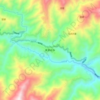
Name: Huangcaoling topographic map, elevation, terrain.
Location: Huangcaoling, Yuanyang County, Honghe, Yunnan, China (22.88800 102.62600 22.96800 102.70600)
Average elevation: 1,057 m
Minimum elevation: 571 m
Maximum elevation: 1,922 m
Other topographic maps
Click on a map to view its topography, its elevation and its terrain.
Honghe Hani Rice Terraces
China > Yunnan > Yuanyang County > Zhulu
The terraces follow a distinct vertical structure that has allowed the landscape to persist for so long, incorporating forests, villages, terraces, and water supply. At the tops of the mountains (above 2000 meters in elevation), the forests are conserved, to act as a catchment for the rainfall and to…
Average elevation: 1,585 m