Geolocate

Mangalbare topographic map

Click on the map to display elevation.

About this map

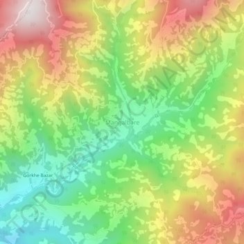
Name: Mangalbare topographic map, elevation, terrain.

Location: Mangalbare, Suryodaya, Ilam District, Koshi Province, 57303, Nepal (26.94417 88.07311 26.98417 88.11311)

Average elevation: 1,713 m

Minimum elevation: 1,234 m

Maximum elevation: 2,305 m

Other topographic maps

Click on a map to view its topography, its elevation and its terrain.

Illam-09

Nepal > Koshi Province > Ilam District

The word ‘Ilam’ comprises two words-‘I’ and ‘Lam’. In Limbu language, the word ‘I’ means ‘winding’ and ‘lam’ denotes the way. The topography of this Ilam aptly depicts several winding paths crisscrossing.

Average elevation: 755 m

Gear up for your next adventure:

🔋Emergency Crank Radio - Weather alerts and power without needing batteries
🧥Waterproof Hiking Jacket - Protect yourself from rain and wind while hiking
Tent Footprint - Protect tent floor and increase durability
🧦Hiking Liner Socks - Thin base layer to prevent friction and blisters
🥾Waterproof Trail Shoes - Shoes designed to handle wet terrain

As an Amazon Associate, this site earns from qualifying purchases at no extra cost to you.