Geolocate

Balabag topographic map

Click on the map to display elevation.

About this map

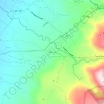
Name: Balabag topographic map, elevation, terrain.

Location: Balabag, Kidapawan, Cotabato, Soccsksargen, Philippines (7.01067 125.16708 7.05067 125.20708)

Average elevation: 789 m

Minimum elevation: 579 m

Maximum elevation: 1,292 m

Other topographic maps

Click on a map to view its topography, its elevation and its terrain.

Pulangi River

Philippines > Cotabato > Kidapawan

Average elevation: 440 m

Gear up for your next adventure:

🚲Bike Repair Kit - Essential tools for on-trail mechanical issues
🔪Outdoor Multitool - Versatile tool for repairs and food prep in the wild
🧢Outdoor Visor - Breathable visor for sunny hikes
🔦UV Flashlight - Detect minerals or specific insects in the dark
🥾Waterproof Hiking Boots - Boots keeping your feet dry in wet conditions

As an Amazon Associate, this site earns from qualifying purchases at no extra cost to you.